Garmin Navionics Vision+™ Chart Card
Please note - we ship Mondays, Wednesdays and Fridays, with a cut-off time of 12pm.
Garmin Navionics Vision+™ Chart Card
Garmin Navionics Vision+™ Australia & New Zealand cartography delivers superior coverage, clarity and detail, combining integrated Garmin and Navionics® coastal and inland content and Relief Shading pre-installed into one premium chart card.
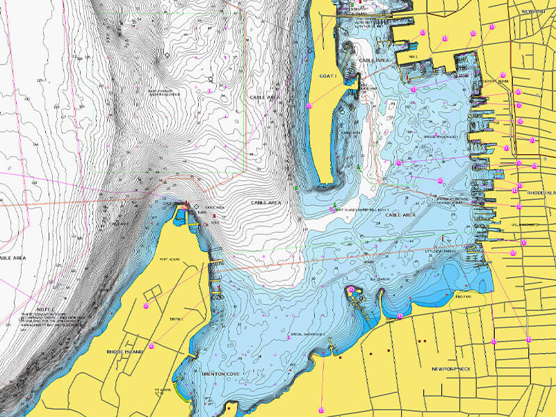
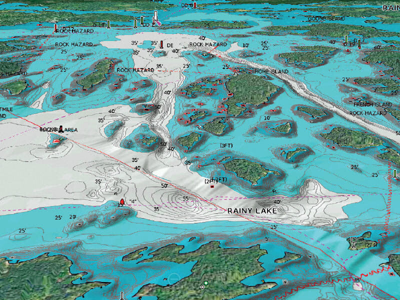
Access detail-rich mapping of coastal features, lakes, rivers and more — with the best offshore and inland lake coverage available for your Garmin chartplotter. This is the top tier of Garmin's charting, adding satellite imagery, aerial photography and 3D views on top of everything included in the standard Garmin Navionics+ range.
What sets Vision+ apart
- Auto Guidance+™ technology — a suggested dock-to-dock path through channels, inlets and marina entrances, combining the best of Garmin and Navionics automatic routing.
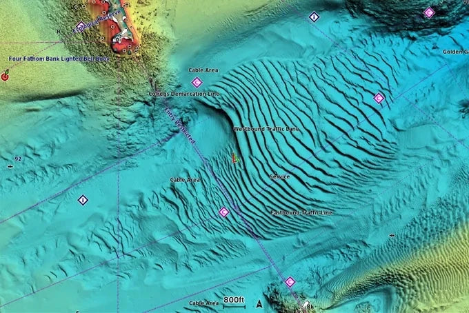
- Relief shading — colour and shadow combined for a far clearer view of bottom structure than contour lines alone.
- High-resolution satellite imagery — superior situational awareness, on screen.
- Aerial photography — crystal-clear imagery of ports, bridges, docks and navigational landmarks for a better sense of your surroundings above the waterline.
- 3D FishEye view — an underwater perspective showing bottom and contours from below the waterline, with the option to interface with your sonar data.
- 3D MarinerEye view — a 3D representation of the surrounding area, both above and below the waterline.
Some Vision+ features (relief shading, satellite imagery) are included as a one-year subscription and require download via the ActiveCaptain® app.
Why Garmin Navionics?
Key Details
Garmin Navionics Vision+™ Chart Card
Garmin Navionics Vision+™ Australia & New Zealand cartography delivers superior coverage, clarity and detail, combining integrated Garmin and Navionics® coastal and inland content and Relief Shading pre-installed into one premium chart card.
Access detail-rich mapping of coastal features, lakes, rivers and more — with the best offshore and inland lake coverage available for your Garmin chartplotter. This is the top tier of Garmin's charting, adding satellite imagery, aerial photography and 3D views on top of everything included in the standard Garmin Navionics+ range.
What sets Vision+ apart
- Auto Guidance+™ technology — a suggested dock-to-dock path through channels, inlets and marina entrances, combining the best of Garmin and Navionics automatic routing.
- Relief shading — colour and shadow combined for a far clearer view of bottom structure than contour lines alone.
- High-resolution satellite imagery — superior situational awareness, on screen.
- Aerial photography — crystal-clear imagery of ports, bridges, docks and navigational landmarks for a better sense of your surroundings above the waterline.
- 3D FishEye view — an underwater perspective showing bottom and contours from below the waterline, with the option to interface with your sonar data.
- 3D MarinerEye view — a 3D representation of the surrounding area, both above and below the waterline.
Some Vision+ features (relief shading, satellite imagery) are included as a one-year subscription and require download via the ActiveCaptain® app.
Why Garmin Navionics?
Key Details
YOU MAY ALSO LIKE


INTERESTED IN OUR PRODUCTS & SERVICES?
SEND US A MESSAGE AND WE'RE HAPPY TO ASSIST!
Fill out the form or reach us via email or phone.
Email: sales@barjimarine.com.au
Phone: 0428025926
Our Customer Care Team is available to help you
from Mondays to Fridays, 8:00AM - 5:00PM.